Have you ever wondered what the USDA Plant Hardiness Zone is? It’s mentioned in every gardening article or the Farmer’s Almanac, but if you’re still not quite sure what it is or what zone you live in, you’re in the right place.
Knowing your USDA Plant Hardiness Zone saves time, money, and heartache, especially when it comes to selecting trees, shrubs, and perennials that are meant to live outdoors year after year. It helps you avoid guesswork, plan winter protection wisely, determine when to start seeds for your garden, and choose plants that actually stand a chance in your climate.
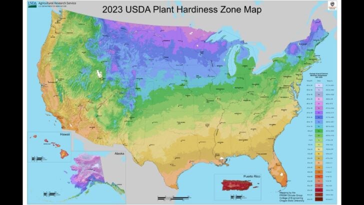
What “Plant Hardiness” Really Means
Plant hardiness is about winter survival, not overall plant health.
The USDA Plant Hardiness Zone Map predicts whether a perennial can survive your coldest winter temperatures, not whether it will grow fast, look lush, or thrive in summer.
As the USDA explains, the map is based on “the average annual extreme minimum winter temperature,” not typical winter weather.
How Zones Are Calculated—and What the Numbers Mean
Zones are divided into 10°F temperature bands, with “a” and “b” subzones representing 5°F differences. Lower numbers mean colder winters; higher numbers mean milder ones. The USDA uses 30-year climate averages to determine the zones and will update the zones as needed as data improves or changes.
Zone 6a isn’t better or worse than 6b; it’s simply colder. That half-step can matter for borderline plants like figs, roses, or blackberries.
The Fastest Way to Find Your Zone
The simplest method to determine your plant hardiness zone is through the official USDA interactive map. Enter your ZIP code, and you’ll see your zone and temperature range instantly.
Just remember: zones are guidance, not a guarantee. A rare cold snap late in the spring can still damage plants rated for your zone. Choose perennials that are rated for your zone, or default to the colder zone if you’re near a boundary. Winter care matters immensely, so use tools like deep mulching, protection such as burlap, and frost covers to help protect your plants.
Why Your Yard Might Feel “Different” Than the Map
Microclimates matter. Cities often run warmer than nearby rural areas due to heat retained by buildings and pavement. Elevation, slopes, and nearby water can also shift winter lows. Newer USDA maps (including the 2023 update) are higher-resolution, showing smaller pockets of variation, but no national map can capture every backyard.
A common misconception is using zones to decide when to plant. Zones don’t tell you if it’s too late to plant onions or when to set out tomatoes; that’s what the last frost dates are for. (You can determine your last frost date on the Farmer’s Almanac first/last frost date calculator.)